HOAM Project, NWT Canada
Geological Setting
The HOAM Project Area lies within the Interior Platform geologic province, a vast basin of Phanerozoic sedimentary rocks lying between the Canadian Shield to the east and the Cordillera to the 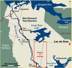 west. Precambrian crystalline and metasedimentary rocks outcrop to the east of the HOAM Project Area and these rocks underlie and form a basement to the Interior Platform sediments. The thickness of the Phanerozoic units varies from a few hundred metres in the eastern part of the HOAM Project Area to in excess of two kilometres in the west.
A study of regional seismic transects across parts of the Interior Platform west and south of Great Bear Lake provided considerable information on the Proterozoic basement sequences, but the review also delineated two extensional regimes that were active during post-Devonian/pre-Cretaceous and post-Cretaceous times. These would have been optimal periods for kimberlite emplacement.
HOAM Project, NWT Canada
A 43-101 Technical Report for the HOAM Project was prepared by Paul Pitman, P.Geo. Mr. Pitman, a “qualified person,” as defined in National Instrument 43-101, is independent of the Corporation. A copy of the HOAM Report is available under the Corporation’s public documents on SEDAR, which can be accessed at www.sedar.com (see December 12, 2014).
This region is considered to be favourable for the emplacement of diamond bearing kimberlites. Prior to Olivut’s involvement in the area, this region was subjected to little modern exploration techniques. High resolution, regional magnetic geophysical surveys, detailed heli-mag geophysical surveys and geochem sampling programs, all conducted by Olivut, have identified several favourable areas for kimberlite occurrence. Olivut has made 29 kimberlite discoveries to date and has additional numerous targets defined for drilling.
The Company has been very successful in identifying kimberlite occurrences in this previously unexplored area of the Northwest Territories. Twenty-nine kimberlite discoveries have been made to date. Although some of the kimberlites are microdiamond bearing, they do not contain the extremely positive diamond inclusion field indicator mineral populations (including G10 garnets) that were previously found in regional stream sediment and till samples in the HOAM Project area. The presence of these high priority indicator minerals warrants continued exploration to discover their source.
In 2013 a detailed helimag program was undertaken to assess moderate to high priority anomalies identified from the ongoing analysis of Olivut’s regional airborne magnetic database. Twenty-three blocks were flown at 50 metre line spacing. The blocks were selected based on logistical parameters to maximize the amount of data that could be obtained within a limited 2013 field budget.
As a result of the 2013 helimag program, seventeen targets were classified as being of moderate to high priority. Several targets are very discreet and are of high interest. 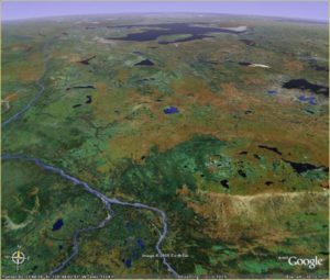
In addition, as part of the 2013 helimag program, a larger helimag block was flown over an area of known kimberlite occurrences to assess regional structures and define weaker magnetic responses. The Company is very pleased with the results from this test area as additional high interest targets were identified; many of these correlate to structural features. These results have positive implications for exploration within the broader region of the HOAM project area.
Exploration on the HOAM Project throughout 2014 to date consisted of more in-depth interpretation of the Company’s extensive regional airborne geophysical database. Modeling of certain targets also has been undertaken. Numerous additional new anomalies have been defined up ice from the high interest kimberlite indicator mineral (KIM) populations. The bedrock sources for these KIMs have yet to be identified. Based on the encouraging results to date, detailed airborne magnetic surveys will be required over these new anomalies. It is anticipated that many additional targets will be added to the list of priority targets already slated to be tested by the next stage of drilling. The Company is evaluating new geophysical technology to ascertain target priority. Depending upon the results of these investigations, a detailed exploration geophysical program and/or drilling may be planned as the next stage of exploration, depending on weather conditions and the availability of financing.
Results of the modelling program and the ongoing geophysical analyses, combined with any additional detailed airborne survey work, should better define known targets and identify new priority drill targets.
Property Description and Location
The HOAM Project Area covers part of the Interior Plains region south of Great Bear Lake in the southwestern part of the Northwest Territories. The community of Fort Simpson is located approximately 15 kms from the HOAM property in the south and the village of Deline is located about 20 kms from the project area in the north.
The HOAM Project Area lies within three traditional Aboriginal settlement regions of the Northwest Territories: the Sahtu in the north, the North Slave in the east and the Deh Cho in the center and south.
Access
Fort Simpson is the major settlement in the region; it is located within the southwestern part of the HOAM Project Area and is linked by the all-weather Mackenzie and Liard Highways to Yellowknife, and to northern Alberta and northern British Columbia. Wrigley is the northern terminus of the Mackenzie Highway. It is about 200 kilometers north of Fort Simpson and is situated along the Mackenzie River just west of the western edge of the HOAM Project Area. Deline is located near the southwestern corner of Great Bear Lake, just north of the HOAM Project Area. The Norman Wells oil fields are located 150 kilometers northwest of the HOAM Project Area. The Enbridge Pipeline from these fields extends along the eastern side of the Mackenzie River, passes by Wrigley and Fort Simpson, through the HOAM project area and extends into northern Alberta.
A few of the larger lakes within the HOAM Project Area can be accessed by fixed wing aircraft on floats but many of the other lakes are too shallow. Places not proximal to these larger lakes must be accessed by helicopter. Scheduled air service links Wrigley, Deline and Fort Simpson with Yellowknife. Commercial trucks operate between Wrigley, Fort Simpson, Yellowknife and southern cities. The Mackenzie River is a major transportation route with commercial barge traffic during summer and fall.
Climate
The average annual mean temperature for the region is about -6°C, averaging 12°C in the summer and -21°C in the winter. Precipitation is about 300 millimeters per year and there are 150 to 200 mean annual snow days. Snow cover lasts from late October to early May with freeze-up occurring in early November and break-up in early May. Summer weather is generally warm, clear and dry.
Topography, Elevation and Vegetation
The HOAM Project Area is situated within the Great Bear and Great Slave Plains, a physiographic region of low relief underlain by nearly flat-lying sedimentary rocks. The Plains are dominated by abundant shallow lakes and ponds, peat and muskeg. The region is forested with black spruce, jack pine and some birch and aspen. Lower cover consists of willows, and a variety of shrubs, moss and lichen. Elevations are generally between 250 and 350 meters but upland areas in the Martin, Ebbut, Shegonla, Notseglee and Ortona Hills are over 600 meters. The highest point in the region is on the southern part of the Horn Plateau at 840 meters.
History
The Interior Platform south of Great Bear Lake has seen relatively little mineral exploration. Essentially all of the work carried out by exploration companies has been directed towards oil and gas and diamonds.